Os grid reference SD.917447. From Kelbrook village head east for 2 miles towards Kelbrook Moor via Heads Lane. Just after the reservoir follow a footpath in a north-easterly direction for about half a mile up the side of the moor. The Pendle Way passes close by here. Beside a farm wall, just below Copy House, is the Dissenters' well with a boundary stone standing at the side.

The so-called Dissenters' Well is a rectangular feature in the ground next to the wall. It is said locally to date from the 17th-18th century but is most probably an ancient moorland spring. The well was in use from the 17th century by Quakers, Baptists, Methodists and possibly Roman Catholics, at a time when there was much animosity towards non-Conformists. Legislation was passed stopping all illegal gatherings to be held within a 5 mile radius of any church - thus leading to religious gatherings in bleak, remote places on the moorland above towns and villages. In 1812 an Act of Parliament against non-Conformists was repealed and dissenters were given equality regarding where they could worship. The water in the well no doubt had some medicinal qualities or, was a source of spiritual up-lift at the time.
By the well there is 3 foot high pointed boundary stone or waymarker that has a thin incised cross carved onto it. The stone is partly embedded in the wall. It probably marks the old boundary between Lancashire and Yorkshire. I don't know who Tom was though he may have been the person who set up the stone. The age of the stone is not known.
Sources:- Oldland, Fay., - The Story Of Foulridge, Pendle Heritage Centre Ltd, 1990.
---------------------------------------------------------------------------------
well after reading the above (on another site) and it being less than 2 miles from home I thought I'd go and check it out.I'm glad it wasn't 20 miles as I spent yesterday afternoon looking for it (the Blog got a photo of a fly at Kelbrook) then last night doing some more reasearch and map work I set off for another go --------------------------------------------------------------------------------
after swapping a couple of e-mails
Hi Ray, OK I know I’m the new boy (old Git really) but have you been ? or just read and copied the source reference ? because I followed Heads Lane passed the reservoir then went north-easterly as per the fairly precise instructions above, then you come back with :-
I think you're in the wrong place Danny, its probably the other copy house at Os grid reference SD.921 431 . My Os grid reference was initially wrong as there are, in fact, two copy houses in that area, the well it is a small, square-shaped feature next to a wall, just south of Copy House Thanks for going up there and looking though. Ray.
the above Grid reference is near to a spring on the path/field wall south-east of what is now Harwes Farm which I thought would be it, but I’m glad it wasn’t. Parked at the Black Lane Ends pub in heavy rain,
went in to ask if I have a pint would it be OK to leave the van in the car park while I tracked an old Well down, Yes No Problem ordered a pint of Copper Dragon “Pippin” Bitter and showed the landlord a copy of the Well info. I’d printed on the back of the map and laminated A4, neither he nor a customer at the bar had heard of it, finished pint and as rain slacked off set off over the fields at the back of the pub
as I topped the rise Pendle Hill came into view
and to the left Nelson
to the right a view down over Kelbrook wood to the other Copy house of yesterdays expedition
Harwes Farm comes into view with Pendle behind
and looking back to Lund’s Tower, Wainmans Pinnacle and the Hitching Stone on the horizon
the last gate before the farm had another carved gate post I seem to have started a synchronicity of with these now another for Mark
But then disaster right where the spring is marked and what I thought the well
there’s plastic progress for you, craftsmanship a work of loving art in the Landscape !
I didn’t see any sign of a boundary stone built into the wall though so walked back then along towards Farm checking the wall nothing, a last look at the map
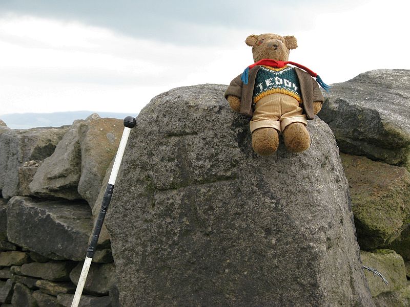
and wait on ! the dot dot dot boundary stone line is in the next field down towards the wood walk along checking the far wall, spot it just to the right of the Oak
Knock on the farm door and explain what I’m up to and show back of map with well info. “No there’s no old wells round here” but very friendly so I explain I think I’ve seen the cross on the boundary stone and would it be OK to walk around the side of the meadow to go and have a look. Yes no problem but there’s no well down there !
It looks a convincing illusion to me and the Bear, for scale the walking pole is 55-1/2” and the proper (Ray!) Grid ref. is SD 92104 43179
I wouldn't like to guess how long the wall to the right will remain standing ?
stopped on the way back for a last look at the well position
I’d carried some of last nights Chilli and Rice in a roasting bag in a billy along with a primus, bottle of wine and a glass but I'm glad I didn’t set up the Bistro as I just made it back to the pub before the next rain shower,
I didn’t eat here though
but this time (in the cause of reasearch) tried the Timothy Taylor Landlord Bitter, they were both superb and on form, with the Timmy Taylor just winning over the Copper Dragon but only just !
I can feel a session coming on,(Beer Monster) maybe camp if there’s ever going to be a summer !
just thought I’d share cheers all Danny
for Mark
looks like the post has been into a couple of gate positions with a few leaded hinge pins, it looks like it's side ways on here ? I've actually leaded a few hinge pins in the past, cup of clay built round and stuck on the post ladle of lead molten on primus or blowlamp and pour
cheers Danny